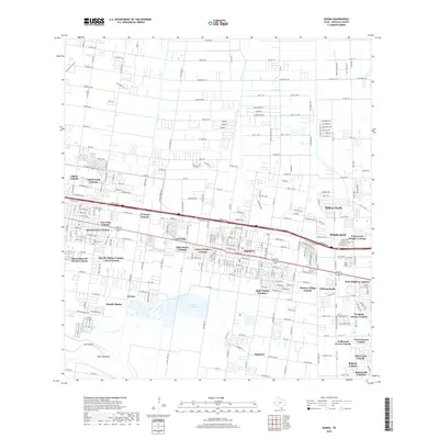
2019 Map of Donna
USGS Topo · Published 2019About this map
Donna and Weslaco anchor this 2019 survey of the Rio Grande Valley, a landscape defined by an intricate network of residential colonias and irrigation management. The map reveals the dense settlement patterns of the region, featuring dozens of named communities such as El Nopal Colonia, Adkins Colonia, and New Palm Colonia. The infrastructure of the valley is clearly marked by the Main Floodway and the expansive Donna Reservoir 1, which reflect the region's managed hydrology. Genealogy researchers will find significant value in the location of Saint Joseph Cemetery and the many small, established neighborhoods like South Alamo and El Gato. The map captures a moment of modern development where established towns meet a patchwork of rural-residential colonias like Villa Donna Colonia and Midway North, illustrating the unique growth trajectory of Hidalgo County.
Find a feature on this map
175 named features on this map. Tap any name to fly to it.
Don’t see what you’re looking for? This feature index may not catch every label — zoom into the map to look around manually.
Map Details
Editions of this 2019 Donna Map
This is the sole edition of this map. No revisions or reprints were ever made.
Other maps of this area

1914 · San Juan
USGS Topo · 1:48,000

1916 · San Juan
USGS Topo · 1:62,500

1949 · Mc Allen
USGS Topo · 1:250,000

1953 · Brownsville
USGS Topo · 1:250,000

1954 · McAllen
USGS Topo · 1:250,000

1956 · Mercedes
USGS Topo · 1:24,000
1956 · Progreso
USGS Topo · 1:24,000

1956 · Brownsville
USGS Topo · 1:250,000

1956 · Port Isabel
USGS Topo · 1:250,000
1957 · Edcouch
USGS Topo · 1:24,000