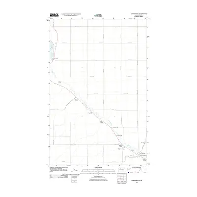
2011 Map of Donnybrook
USGS Topo · Published 2011About this map
Donnybrook sits at the base of a complex drainage network where the Des Lacs River cuts a deep, winding valley through the high prairie. This landscape is defined by its numerous coulees—dry canyons that channel runoff into the river—many of which bear the names of early settlers, such as McIntosh Coulee, Aennis Coulee, and Spencer Coulee. The map illustrates the sharp contrast between the flat, gridded agricultural uplands, partitioned by roads like 366th Ave NW and 408th St NW, and the irregular, erosion-carved river valley. In the southeastern corner, the concentration of named landmarks like Church Hill and Mike King Hill near the town center highlights the importance of local topography in the community's layout. Genealogists may find interest in the location of Holbrook Cemetery, positioned on the valley slope overlooking the river, and the infrastructure of Dam Number 8 to the northwest.
Find a feature on this map
35 named features on this map. Tap any name to fly to it.
Don’t see what you’re looking for? This feature index may not catch every label — zoom into the map to look around manually.
Map Details
Editions of this 2011 Donnybrook Map
This is the sole edition of this map. No revisions or reprints were ever made.
Other maps of this area
1947 · Tolley
USGS Topo · 1:62,500
1948 · Kenmare
USGS Topo · 1:24,000
1948 · Norma
USGS Topo · 1:24,000
1948 · Tolley
USGS Topo · 1:24,000
1948 · Donnybrook
USGS Topo · 1:24,000
1949 · Tolley SE
USGS Topo · 1:24,000
1949 · Hartland
USGS Topo · 1:24,000
1949 · Coulee
USGS Topo · 1:24,000
1950 · Kenmare
USGS Topo · 1:62,500
1950 · Tolley
USGS Topo · 1:62,500