
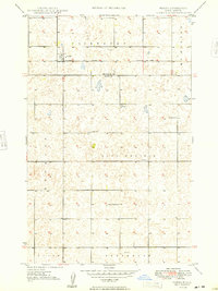
1948 Map of Norma
USGS Topo · Published 1948About this map
The small settlement of Norma anchors the northern portion of this 1940s landscape, positioned along the prominent line of the Minneapolis St Paul and Sault Ste Marie railroad. The map reveals a post-war rural infrastructure defined by its section-line organization and communal hubs, including a central Town Hall in the Sauk Prairie district. Educational life is visible through the placement of several local institutions, specifically School No 1, School No 3, and School No 4, which served the surrounding farming families. This survey is particularly notable for its high density of small depressions and potholes, characteristic of the glaciated terrain spanning the Renville Co Ward Co border. A single Windmill stands near the southern edge in Greenbush, reflecting the localized water management essential for these North Dakota plains.
Find a feature on this map
14 named features on this map. Tap any name to fly to it.
Don’t see what you’re looking for? This feature index may not catch every label — zoom into the map to look around manually.
Map Details
Editions of this 1948 Norma Map
2 editions found
Other maps of this area

1947 · Tolley
USGS Topo · 1:62,500

1948 · Kenmare
USGS Topo · 1:24,000

1948 · Tolley
USGS Topo · 1:24,000

1948 · Donnybrook
USGS Topo · 1:24,000

1949 · Tolley SE
USGS Topo · 1:24,000

1949 · Bowbells SE
USGS Topo · 1:24,000

1949 · Coulee
USGS Topo · 1:24,000

1949 · Mouse River Park SW
USGS Topo · 1:24,000

1949 · Mouse River Park
USGS Topo · 1:24,000

1950 · Bowbells
USGS Topo · 1:62,500