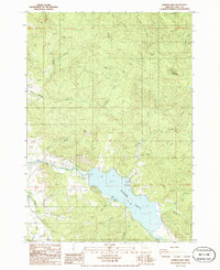
1986 Map of Dorena Lake
USGS Topo · Published 1988About this map
Dorena Lake serves as the central anchor of this mid-1980s landscape, where the Row River and several smaller tributaries like Gettings Creek and Mosby Creek feed into the reservoir. The map documents a recreational and industrial transition, featuring public spaces such as Schwartz Park and Baker Bay Park alongside infrastructure like a Sub Sta and a Quarry. Transportation history is visible through the Old RR Grade winding along the riverbank and the Trans Line cutting through the terrain. Civil engineering and local connectivity are noted by the presence of the Currin Bridge and Stewart Bridge, which provide crossings near the settlement of Dorena. The surrounding topography is marked by prominent heights including Cerro Gordo and Bear Mountain, reflecting the varied elevations of the Lane County landscape before later development altered these rural corridors.
Find a feature on this map
40 named features on this map. Tap any name to fly to it.
Don’t see what you’re looking for? This feature index may not catch every label — zoom into the map to look around manually.
Map Details
Editions of this 1986 Dorena Lake Map
This is the sole edition of this map. No revisions or reprints were ever made.
Other maps of this area

1921 · Cottage Grove
USGS Topo · 1:62,500

1935 · Lowell
USGS Topo · 1:96,000

1942 · Lowell
USGS Topo · 1:125,000

1954 · Anlauf
USGS Topo · 1:62,500

1955 · Culp Creek
USGS Topo · 1:62,500

1955 · Lowell
USGS Topo · 1:62,500
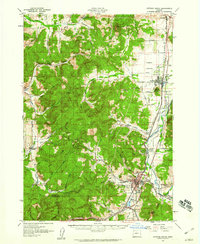
1957 · Cottage Grove
USGS Topo · 1:62,500

1958 · Roseburg
USGS Topo · 1:250,000

1959 · Roseburg
USGS Topo · 1:250,000

1979 · Cottage Grove
USGS Topo · 1:100,000