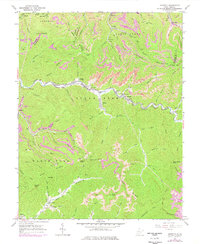
1965 Map of Dorothy
USGS Topo · Published 1977About this map
Kayford Mountain dominates the central topography of this mid-1960s survey, where the borders of Boone, Raleigh, Kanawha, and Fayette counties converge. The rugged landscape is defined by the narrow valleys of the Clear Fork, Marsh Fork River, and Coal River, which serve as the primary corridors for settlement and industry. The Chesapeake and Ohio railroad follows the winding path of the Clear Fork, connecting coal-town communities like Dorothy, Colcord, and Ameagle.
Find a feature on this map
83 named features on this map. Tap any name to fly to it.
Don’t see what you’re looking for? This feature index may not catch every label — zoom into the map to look around manually.
Map Details
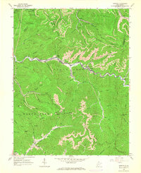
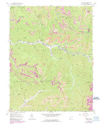
Editions of this 1965 Dorothy Map
3 editions found
Other maps of this area

1891 · Oceana
USGS Topo · 1:125,000

1891 · Raleigh
USGS Topo · 1:125,000

1893 · Oceana
USGS Topo · 1:125,000

1897 · Kanawha Falls
USGS Topo · 1:125,000

1897 · Raleigh
USGS Topo · 1:125,000

1898 · Oceana
USGS Topo · 1:125,000

1899 · Charleston
USGS Topo · 1:125,000

1900 · Kanawha Falls
USGS Topo · 1:125,000

1901 · Kanawha Falls
USGS Topo · 1:125,000

1902 · Raleigh
USGS Topo · 1:125,000