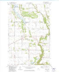
1982 Map of Dorothy
USGS Topo · Published 1982About this map
The tiny settlement of Dorothy and the nearby St Dorothys Ch anchor this rural landscape at the crossroads of several Minnesota counties. Located at the intersection of Polk, Pennington, and Red Lake counties, the map highlights a terrain defined by extensive drainage efforts and conservation areas. The northern expanse is dominated by the Goose Lake Swamp, partially preserved within the Pembina State Wildlife Management Area. Numerous man-made channels like County Ditch No 147 and Lateral No 4 Ditch cut through the townships of Wylie, Louisville, and Polk Centre, illustrating the intensive modification of the Red River Valley for agriculture. The serpentine course of the Red Lake River winds through the southern reaches, flanked by the Moran State Wildlife Management Area, while an Old Railroad Grade provides a trace of former transportation networks through the center of the sheet.
Find a feature on this map
21 named features on this map. Tap any name to fly to it.
Don’t see what you’re looking for? This feature index may not catch every label — zoom into the map to look around manually.
Map Details
Editions of this 1982 Dorothy Map
This is the sole edition of this map. No revisions or reprints were ever made.
Other maps of this area

1918 · Angus
USGS Topo · 1:62,500

1918 · Red Lake Falls
USGS Topo · 1:62,500

1918 · Viking
USGS Topo · 1:62,500

1952 · Red Lake Falls
USGS Topo · 1:62,500

1952 · Grand Forks
USGS Topo · 1:250,000

1952 · Thief River Falls
USGS Topo · 1:250,000

1953 · Crookston
USGS Topo · 1:62,500

1956 · Thief River Falls
USGS Topo · 1:250,000

1956 · Grand Forks
USGS Topo · 1:250,000

1957 · Thief River Falls
USGS Topo · 1:250,000