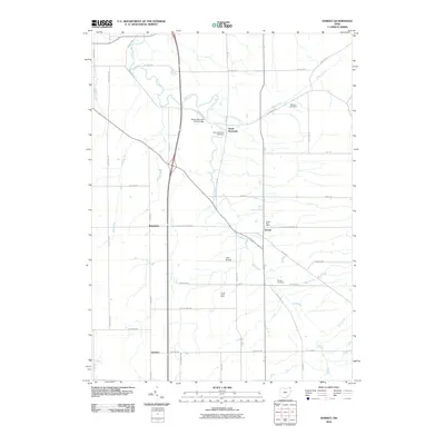
2010 Map of Dorset
USGS Topo · Published 2010About this map
Mill Creek winds through the rural heart of Ashtabula County, anchoring a landscape defined by small crossroads settlements and family farms. This area, captured in the early 21st century, maintains a traditional township grid where Dorset serves as a primary community hub, complete with its own Dorset Post Office. The map reveals a high density of genealogical sites, including the Dorset Cemetery, South Denmark Cemetery, and Williams Cemetery, which are tucked away along quiet routes like S Denmark Rd and Marrian Rd. To the west, the tiny hamlet of Rowenton sits near the headwaters of Askue Run, while the southern reaches feature the Sentinel settlement. Agriculture remains a central pillar of the local economy, evidenced by the named Comp Dairy Farm and the specialized infrastructure of the Allen Airport, which serves this corner of northeast Ohio.
Find a feature on this map
41 named features on this map. Tap any name to fly to it.
Don’t see what you’re looking for? This feature index may not catch every label — zoom into the map to look around manually.
Map Details
Editions of this 2010 Dorset Map
This is the sole edition of this map. No revisions or reprints were ever made.
Other maps of this area

1905 · Andover
USGS Topo · 1:48,000

1905 · Ashtabula
USGS Topo · 1:62,500

1905 · Jefferson
USGS Topo · 1:62,500

1906 · Conneaut
USGS Topo · 1:62,500

1907 · Andover
USGS Topo · 1:62,500

1907 · Jefferson
USGS Topo · 1:62,500

1950 · Cleveland
USGS Topo · 1:250,000

1956 · Cleveland
USGS Topo · 1:250,000

1959 · Dorset
USGS Topo · 1:24,000
1959 · Andover
USGS Topo · 1:24,000