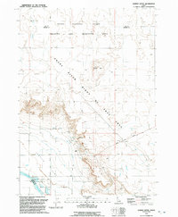
1992 Map of Dorsey Butte
USGS Topo · Published 1992About this map
The Snake River carves through this Idaho landscape, defining the transition from the basaltic highlands of Dorsey Butte down to the low-lying Chattin Flat. In the early 1990s, much of the northern terrain was dedicated to the Idaho National Guard Training and Maneuver Area, a purpose-driven landscape of open range and access tracks. Along the river's edge, conservation efforts are prominent, with the Snake River Birds of Prey Area and the Trueblood Wildlife Area protecting the riparian corridor. Traces of human utility and water management appear throughout the arid flats, including a Canal and a prominent Levee near the southern bend, while the Grand View Highway provides the primary transit link through the region's expansive topography.
Find a feature on this map
21 named features on this map. Tap any name to fly to it.
Don’t see what you’re looking for? This feature index may not catch every label — zoom into the map to look around manually.
Map Details
Editions of this 1992 Dorsey Butte Map
This is the sole edition of this map. No revisions or reprints were ever made.
Other maps of this area

1892 · Mountain Home
USGS Topo · 1:125,000

1892 · Bisuka
USGS Topo · 1:125,000

1893 · Mountain Home
USGS Topo · 1:125,000

1894 · Bisuka
USGS Topo · 1:125,000

1946 · Mouth of Bruneau
USGS Topo · 1:24,000

1947 · Grand View
USGS Topo · 1:62,500

1947 · Bruneau
USGS Topo · 1:62,500

1947 · Grand View
USGS Topo · 1:24,000

1947 · Jackass Butte
USGS Topo · 1:24,000

1947 · Vinson Wash
USGS Topo · 1:24,000