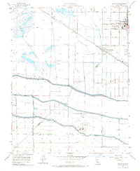
1956 Map of Dos Palos
USGS Topo · Published 1967About this map
The agricultural and water management systems of the San Joaquin Valley dominate this landscape, where the Merced Co Fresno Co line divides a network of reclaimed land and irrigation infrastructure. The Southern Pacific railroad runs through the primary settlements, connecting Dos Palos to South Dos Palos, while the massive Delta Mendota Canal and the Outside Canal carve engineered paths across the terrain. These waterways reflect the mid-century expansion of California's water delivery systems under the direction of Harvey O. Banks.
Find a feature on this map
33 named features on this map. Tap any name to fly to it.
Don’t see what you’re looking for? This feature index may not catch every label — zoom into the map to look around manually.
Map Details
Editions of this 1956 Dos Palos Map
4 editions found
Other maps of this area

1913 · Panoche
USGS Topo · 1:125,000

1916 · Santa Rita Bridge
USGS Topo · 1:24,000

1916 · Delta Ranch
USGS Topo · 1:24,000

1920 · Santa Rita Bridge
USGS Topo · 1:31,680

1921 · Los Banos
USGS Topo · 1:31,680

1921 · Laguna Seca Ranch
USGS Topo · 1:31,680

1922 · Oxalis
USGS Topo · 1:31,680

1922 · Santa Rita Bridge
USGS Topo · 1:31,680

1922 · Charleston School
USGS Topo · 1:31,680

1922 · Dos Palos
USGS Topo · 1:31,680