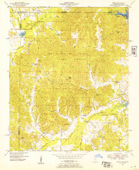
1950 Map of Doskie
USGS Topo · Published 1954About this map
The Tennessee-Mississippi state line divides this 1950s landscape, where the waters of the newly formed Pickwick Lake meet the rugged hills of the Tishomingo County Game Refuge. The area shows a rural society centered around small country institutions, including the Lambs Chapel School and its nearby Lambs Chapel Cem, as well as Center Point School and Barnes Chapel School. These landmarks, along with many family-named features like Barnes Yankee Charlie Hollow, provide a detailed record of local geography before the mid-century.
Find a feature on this map
83 named features on this map. Tap any name to fly to it.
Don’t see what you’re looking for? This feature index may not catch every label — zoom into the map to look around manually.
Map Details
Editions of this 1950 Doskie Map
3 editions found
Other maps of this area

1911 · Iuka
USGS Topo · 1:48,000

1914 · Iuka
USGS Topo · 1:62,500

1935 · Doskie
USGS Topo · 1:24,000

1935 · Iuka
USGS Topo · 1:24,000

1935 · Leedy
USGS Topo · 1:24,000

1935 · Glens
USGS Topo · 1:24,000

1936 · Counce
USGS Topo · 1:24,000

1936 · Kendrick
USGS Topo · 1:24,000

1936 · Shaws
USGS Topo · 1:24,000

1936 · Pickwick
USGS Topo · 1:24,000