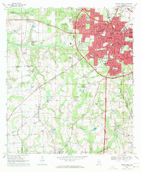
1969 Map of Dothan West
USGS Topo · Published 1971About this map
Dothan serves as the focal point of this 1969 survey, showing a rapidly developing urban core surrounded by traditional Wiregrass region agriculture. The map documents significant local infrastructure including the Flowers Hospital, Moody Hospital, and the Houston County Library near the city center. Three major rail lines—the Central of Georgia, Atlantic and Saint Andrews Bay, and Seaboard Coast Line—converge here, reflecting the city's importance as a transportation and trade hub for southeastern Alabama.
Find a feature on this map
69 named features on this map. Tap any name to fly to it.
Don’t see what you’re looking for? This feature index may not catch every label — zoom into the map to look around manually.
Map Details
Editions of this 1969 Dothan West Map
2 editions found
Other maps of this area

1942 · Enterprise
USGS Topo · 1:125,000

1948 · Ozark
USGS Topo · 1:62,500

1950 · Ozark
USGS Topo · 1:62,500

1953 · Dothan
USGS Topo · 1:250,000

1954 · Dothan
USGS Topo · 1:250,000

1955 · Dothan
USGS Topo · 1:250,000

1957 · Malvern
USGS Topo · 1:24,000

1957 · Hartford
USGS Topo · 1:62,500
1957 · Slocomb
USGS Topo · 1:24,000

1960 · Pinckard
USGS Topo · 1:24,000