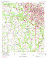
1969 Map of Dothan West
USGS Topo · Published 1981About this map
Dothan's western edge reveals a city in transition, where the expanding urban grid of the 1960s and 1970s meets the older agrarian landscape of Houston County. The dense municipal center, marked by landmarks like the Flowers Hospital and the Central of Georgia railroad, gives way to a sprawling rural-to-urban fringe. Notable among the industrial and transport infrastructure is the Old Dothan Airport (Abandoned), north of the modern city core, signifying a shift in the region's aviation needs during this era.
Find a feature on this map
65 named features on this map. Tap any name to fly to it.
Don’t see what you’re looking for? This feature index may not catch every label — zoom into the map to look around manually.
Map Details
Editions of this 1969 Dothan West Map
2 editions found
Other maps of this area

1942 · Enterprise
USGS Topo · 1:125,000

1948 · Ozark
USGS Topo · 1:62,500

1950 · Ozark
USGS Topo · 1:62,500

1953 · Dothan
USGS Topo · 1:250,000

1954 · Dothan
USGS Topo · 1:250,000

1955 · Dothan
USGS Topo · 1:250,000

1957 · Malvern
USGS Topo · 1:24,000

1957 · Hartford
USGS Topo · 1:62,500
1957 · Slocomb
USGS Topo · 1:24,000

1960 · Pinckard
USGS Topo · 1:24,000