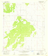
1958 Map of Double Adobe
USGS Topo · Published 1959About this map
Sulphur Spring Valley dominates this 1950s landscape, characterized by the wide, intermittent drainage of Whitewater Draw and its many smaller tributaries. The small settlement of Double Adobe sits at a junction of local roads, serving as a primary focal point for the surrounding cattle country. This era in Cochise County history shows a transition toward modern infrastructure, indicated by the prominent Pipeline cutting across the northeastern corner and the established Elfrida Cutoff. Ranching life is evidenced by the Lazy KJ Ranch, while aviation history is represented by the remote Forrest Airport located near the southern boundary. Survey markers like VABM Lamb 4084 provide precise elevation data for this high-desert basin, which remains largely open range and sparsely populated during this survey period.
Find a feature on this map
11 named features on this map. Tap any name to fly to it.
Don’t see what you’re looking for? This feature index may not catch every label — zoom into the map to look around manually.
Map Details
Editions of this 1958 Double Adobe Map
3 editions found
Other maps of this area

1902 · Bisbee
USGS Topo · 1:62,500

1910 · Bisbee
USGS Topo · 1:62,500

1914 · Douglas
USGS Topo · 1:62,500

1916 · Pearce
USGS Topo · 1:125,000

1916 · Douglas
USGS Topo · 1:125,000

1919 · Douglas
USGS Topo · 1:125,000

1922 · Swisshelm
USGS Topo · 1:62,500

1925 · Douglas
USGS Topo · 1:62,500

1925 · Gleeson
USGS Topo · 1:62,500

1927 · Bisbee
USGS Topo · 1:62,500