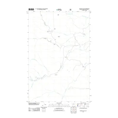
2011 Map of Double Falls
USGS Topo · Published 2011About this map
Lime Ridge and McCarty Hill overlook a landscape defined by ranching and high-country recreation in Lewis and Clark County. This 2011 survey details a network of drainage systems, including Willow Creek and Ford Creek, which gather at the namesake Double Falls in the southwestern portion of the map. The distribution of ranching properties like Hidden Valley Ranch, Scoutana Ranch, and Weisner Ranch illustrates the enduring land-use patterns of this Montana region. A localized water management infrastructure is evident near the eastern boundary at the Really Red Dam. Accessible via Benchmark Rd and Beaver Willow Rd, the area serves as a gateway to mountain terrain, anchored by sites like the Ford Creek Resort and the Willow Creek Cabin.
Find a feature on this map
25 named features on this map. Tap any name to fly to it.
Don’t see what you’re looking for? This feature index may not catch every label — zoom into the map to look around manually.
Map Details
Editions of this 2011 Double Falls Map
This is the sole edition of this map. No revisions or reprints were ever made.
Other maps of this area

1903 · Saypo
USGS Topo · 1:125,000

1903 · Coopers Lake
USGS Topo · 1:125,000

1955 · Choteau
USGS Topo · 1:250,000

1957 · Choteau
USGS Topo · 1:250,000

1958 · Choteau
USGS Topo · 1:250,000

1958 · Barr Creek
USGS Topo · 1:24,000

1958 · Sawtooth Ridge
USGS Topo · 1:24,000

1958 · Patricks Basin
USGS Topo · 1:24,000

1962 · Choteau
USGS Topo · 1:250,000
1970 · Scapegoat Mountain
USGS Topo · 1:24,000