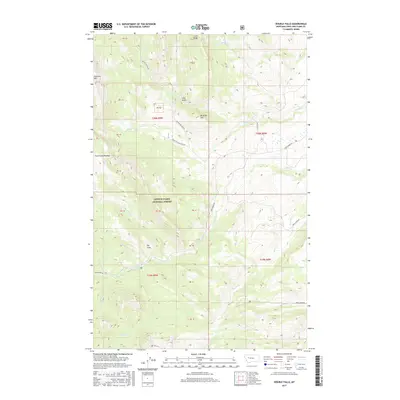
2017 Map of Double Falls
USGS Topo · Published 2017About this map
Lewis & Clark National Forest encompasses the high-altitude terrain of this region, defined by complex drainage networks and dramatic elevation changes. The namesake Double Falls is a central landmark along Ford Cr, which cuts through the center of the sheet below the elevated The Steps. The landscape is dominated by notable heights such as Fairview Mtn in the northwest and McCarty Hill, providing a look at the geological transitions between Lime Ridge and the Ford Creek Plateau. Road access during this era is concentrated along routes like Beaver Willow Rd and the Augusta Ranger Sta Rd, reflecting the management and recreational infrastructure of the national forest. Numerous waterways, including White-water Cr and N Fork Willow Cr, illustrate the intricate hydrography of the Front Range.
Find a feature on this map
35 named features on this map. Tap any name to fly to it.
Don’t see what you’re looking for? This feature index may not catch every label — zoom into the map to look around manually.
Map Details
Editions of this 2017 Double Falls Map
This is the sole edition of this map. No revisions or reprints were ever made.
Other maps of this area

1903 · Saypo
USGS Topo · 1:125,000

1903 · Coopers Lake
USGS Topo · 1:125,000

1955 · Choteau
USGS Topo · 1:250,000

1957 · Choteau
USGS Topo · 1:250,000

1958 · Choteau
USGS Topo · 1:250,000

1958 · Barr Creek
USGS Topo · 1:24,000

1958 · Sawtooth Ridge
USGS Topo · 1:24,000

1958 · Patricks Basin
USGS Topo · 1:24,000

1962 · Choteau
USGS Topo · 1:250,000
1970 · Scapegoat Mountain
USGS Topo · 1:24,000