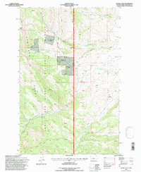
1995 Map of Double Falls
USGS Topo · Published 1997About this map
The Sawtooth Range and the Lewis and Clark Range converge in this high-altitude landscape within the Lewis and Clark National Forest. The map documents a rugged mountain environment defined by deep drainage basins and significant ridgelines like Lime Ridge and McCarty Hill. Private landholdings and small outposts are scattered throughout the federal territory, including the Hidden Valley Ranch, Scoutana Ranch, and the Fish and Game Cabin. Waterways like Willow Creek and Ford Creek carve through the terrain, leading toward the namesake Double Falls in the southern portion of the quadrangle. For recreational history, the map traces the Petty Crown Nat Rec Trail, while smaller features like the Cobb Ranch and Weisner Ranch provide points of interest for genealogists and local historians.
Find a feature on this map
28 named features on this map. Tap any name to fly to it.
Don’t see what you’re looking for? This feature index may not catch every label — zoom into the map to look around manually.
Map Details
Editions of this 1995 Double Falls Map
This is the sole edition of this map. No revisions or reprints were ever made.
Other maps of this area

1903 · Saypo
USGS Topo · 1:125,000

1903 · Coopers Lake
USGS Topo · 1:125,000

1955 · Choteau
USGS Topo · 1:250,000

1957 · Choteau
USGS Topo · 1:250,000

1958 · Choteau
USGS Topo · 1:250,000

1958 · Barr Creek
USGS Topo · 1:24,000

1958 · Sawtooth Ridge
USGS Topo · 1:24,000

1958 · Patricks Basin
USGS Topo · 1:24,000

1962 · Choteau
USGS Topo · 1:250,000
1970 · Scapegoat Mountain
USGS Topo · 1:24,000