
1965 Map of Double Lakes
USGS Topo · Published 1967About this map
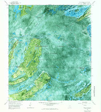
Okefenokee National Wildlife Refuge dominates this experimental photomap, which utilizes a controlled mosaic of 1963 aerial photography to reveal the intricate hydrology of the Okefenokee Swamp. The landscape is a complex network of open water and aquatic prairies, including Double Lakes, Carters Prairie, and Redbird Prairie. This specific mapping method provides an exceptional view of the hammocks and islands that break the swamp surface, most notably the long, wooded stretch of Floyds Island. Along the eastern edge, the topography shifts to slightly higher ground where primitive routes like Sawfly Road and Perimeter Road skirt the wetlands. Human activity within the refuge is concentrated at Kings Boat Landing, providing a point of entry into the labyrinth of named water bodies such as Durdin Lake and Mose Lake.
Find a feature on this map
35 named features on this map. Tap any name to fly to it.
Don’t see what you’re looking for? This feature index may not catch every label — zoom into the map to look around manually.
Map Details
Editions of this 1965 Double Lakes Map
This is the sole edition of this map. No revisions or reprints were ever made.
Other maps of this area

1918 · Folkston
USGS Topo · 1:62,500

1953 · Waycross
USGS Topo · 1:250,000

1954 · Valdosta
USGS Topo · 1:250,000

1958 · Valdosta
USGS Topo · 1:250,000

1958 · Waycross
USGS Topo · 1:250,000

1959 · Valdosta
USGS Topo · 1:250,000

1965 · Chase Prairie
USGS Topo · 1:24,000

1965 · Dinner Pond
USGS Topo · 1:24,000
1966 · Billys Island
USGS Topo · 1:24,000
1966 · Winokur
USGS Topo · 1:24,000