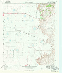
1968 Map of Dougherty
USGS Topo · Published 1971About this map
The Quanah Acme and Pacific rail line cuts a straight path across the High Plains of West Texas in this late-1960s survey, anchoring the small settlement of Dougherty. This area, situated along the Floyd Co Motley Co line, reveals a landscape defined by agricultural utility and early aviation. Local transit and commerce are represented by features like the Lloyd Airfield, Norman Airfield, and a central Substa near the tracks. To the east, the terrain breaks into the more complex drainage of the Rolling Plains, where Dutchman Creek and Wolf Creek begin their descent from the caprock. Social and travel markers of the era are also present, including Burleson and the Campbell Roadside Park, providing a window into the rural infrastructure of the Llano Estacado before modern expansion.
Find a feature on this map
13 named features on this map. Tap any name to fly to it.
Don’t see what you’re looking for? This feature index may not catch every label — zoom into the map to look around manually.
Map Details
Editions of this 1968 Dougherty Map
This is the sole edition of this map. No revisions or reprints were ever made.
Other maps of this area

1954 · Lubbock
USGS Topo · 1:250,000

1954 · Plainview
USGS Topo · 1:250,000

1958 · Plainview
USGS Topo · 1:250,000

1965 · Wake
USGS Topo · 1:24,000

1965 · Boothe
USGS Topo · 1:24,000

1966 · Lockney 4 SW
USGS Topo · 1:24,000

1966 · Mount Blanco
USGS Topo · 1:24,000

1967 · Dick Moore Canyon
USGS Topo · 1:24,000

1967 · Whiteflat
USGS Topo · 1:24,000

1968 · Mac Bain
USGS Topo · 1:24,000