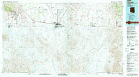
1994 Map of Douglas
USGS Topo · Published 1994About this map
The industrial footprint of the Mule Mountains dominates the western portion of this 1994 survey, centering on the massive operations at the Copper Queen Mine and the Lavender Pit. The complex relationship between the mining settlements of Bisbee, Lowell, and Warren is clearly delineated alongside the Southern Pacific rail lines that once fueled the regional economy. To the east, the landscape transitions into the open expanse of the San Bernardino Valley, where the San Bernardino National Wildlife Refuge preserves a critical riparian corridor along Black Draw.
Find a feature on this map
47 named features on this map. Tap any name to fly to it.
Don’t see what you’re looking for? This feature index may not catch every label — zoom into the map to look around manually.
Map Details
Editions of this 1994 Douglas Map
2 editions found
Other maps of this area

1902 · Bisbee
USGS Topo · 1:62,500

1910 · Bisbee
USGS Topo · 1:62,500

1914 · Hereford
USGS Topo · 1:125,000

1914 · Douglas
USGS Topo · 1:62,500

1915 · Benson
USGS Topo · 1:125,000

1916 · Pearce
USGS Topo · 1:125,000

1916 · Douglas
USGS Topo · 1:125,000

1917 · Chiricahua
USGS Topo · 1:125,000

1918 · Cienega Springs
USGS Topo · 1:62,500

1918 · Animas Peak
USGS Topo · 1:62,500