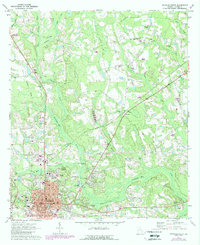
1971 Map of Douglas North
USGS Topo · Published 1988About this map
Douglas serves as the focal point of this Coffee County landscape, showing a dense grid of streets and civic infrastructure including the Courthouse, Po, and City Hall. The surrounding rural territory is defined by a network of drainage basins, most notably the Seventeen Mile River and Twenty Mile Creek, which carve through the woodland and agricultural fields. Smaller rural nodes like Lotts and Huffer appear along the transportation routes, while an Old Railroad Grade north of Douglas marks a legacy of earlier transit patterns. This 1971 survey, with 1983 photo-revisions, documents a community balancing its municipal growth with rural traditions. The map is particularly rich in genealogy potential, recording numerous community anchors such as Harrel Cem Ch, Shady Grove Ch, and the Oak Grove Cem, reflecting the distribution of early families across the countryside.
Find a feature on this map
42 named features on this map. Tap any name to fly to it.
Don’t see what you’re looking for? This feature index may not catch every label — zoom into the map to look around manually.
Map Details
Editions of this 1971 Douglas North Map
2 editions found
Other maps of this area

1953 · Waycross
USGS Topo · 1:250,000

1958 · Waycross
USGS Topo · 1:250,000

1971 · Douglas North
USGS Topo · 1:24,000

1971 · Douglas South
USGS Topo · 1:24,000

1971 · Nicholls
USGS Topo · 1:24,000

1971 · Wilsonville
USGS Topo · 1:24,000

1971 · Broxton NE
USGS Topo · 1:24,000

1971 · Denton
USGS Topo · 1:24,000

1972 · Broxton North
USGS Topo · 1:24,000

1972 · Mora
USGS Topo · 1:24,000