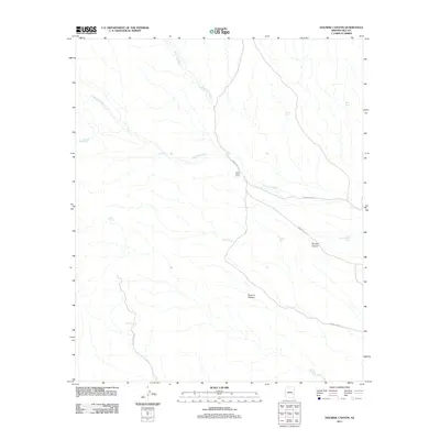
2011 Map of Dourine Canyon
USGS Topo · Published 2011About this map
Circle Seven Ranch sits at a critical junction of drainage and transportation in this arid Gila County landscape. The ranch is positioned where the seasonal Sevenmile Wash meets Indian Rte-1001, a geography defined by the necessity of water management. Numerous artificial catchments like Granite Butte Tank, Steer Tank, and Quail Mesa Tank are scattered across the terrain to support livestock in the Dourine Pasture. The land is deeply etched by the descent of Champion Creek and the eponymous Dourine Canyon, illustrating the remote ranching infrastructure of the early 21st century. Access is provided by a network of local routes including Skill Center Rd and Indian Rte-903, which navigate the complex topography and connect isolated springs such as Indian Spring to the broader regional corridor.
Find a feature on this map
17 named features on this map. Tap any name to fly to it.
Don’t see what you’re looking for? This feature index may not catch every label — zoom into the map to look around manually.
Map Details
Editions of this 2011 Dourine Canyon Map
This is the sole edition of this map. No revisions or reprints were ever made.
Other maps of this area

1922 · Chrysotile
USGS Topo · 1:125,000

1954 · Mesa
USGS Topo · 1:250,000

1957 · Mesa
USGS Topo · 1:250,000

1958 · Mesa
USGS Topo · 1:250,000

1960 · Mesa
USGS Topo · 1:250,000

1964 · Mesa
USGS Topo · 1:250,000

1965 · Bucket Mtn
USGS Topo · 1:24,000

1966 · Natural Corral
USGS Topo · 1:24,000
1966 · Dourine Canyon
USGS Topo · 1:24,000

1966 · Cassadore Spring
USGS Topo · 1:24,000