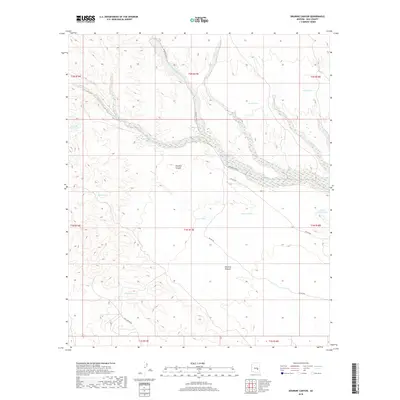
2018 Map of Dourine Canyon
USGS Topo · Published 2018About this map
Dourine Canyon and the expansive drainage of Sevenmile Wash define this landscape in the heart of Gila County. The 2018 survey reveals a terrain shaped by water management for livestock, with a dense network of earthen reservoirs including Dourine Tank, Steer Tank, and Quail Mesa Tank. These tanks, along with Indian Spring, provide critical water points across the high desert, illustrating the ranching infrastructure of Dourine Pasture. The map highlights the confluence of Champion Cr and the main wash, which serve as the primary topographical anchors for the region. Transportation is limited to a handful of routes, notably Bia RD 900 and Skill Center Rd, which navigate the elevation changes between Granite Butte Tank and the surrounding mesas.
Find a feature on this map
23 named features on this map. Tap any name to fly to it.
Don’t see what you’re looking for? This feature index may not catch every label — zoom into the map to look around manually.
Map Details
Editions of this 2018 Dourine Canyon Map
This is the sole edition of this map. No revisions or reprints were ever made.
Other maps of this area

1922 · Chrysotile
USGS Topo · 1:125,000

1954 · Mesa
USGS Topo · 1:250,000

1957 · Mesa
USGS Topo · 1:250,000

1958 · Mesa
USGS Topo · 1:250,000

1960 · Mesa
USGS Topo · 1:250,000

1964 · Mesa
USGS Topo · 1:250,000

1965 · Bucket Mtn
USGS Topo · 1:24,000

1966 · Natural Corral
USGS Topo · 1:24,000
1966 · Dourine Canyon
USGS Topo · 1:24,000

1966 · Cassadore Spring
USGS Topo · 1:24,000