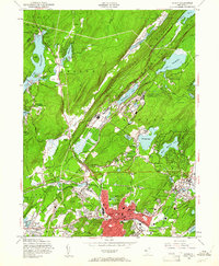
1954 Map of Dover
USGS Topo · Published 1961About this map
The industrial and military landscape of northern New Jersey is prominently displayed here, centered on the Dover urban core and the sprawling Picatinny Arsenal. The map documents a period of significant post-war infrastructure, showing the dense rail network including the Central RR of New Jersey and the Delaware Lackawanna and Western RR that serviced the region's mines and munitions works.
Find a feature on this map
83 named features on this map. Tap any name to fly to it.
Don’t see what you’re looking for? This feature index may not catch every label — zoom into the map to look around manually.
Map Details
Editions of this 1954 Dover Map
5 editions found

Other maps of this area

1888 · Franklin
USGS Topo · 1:62,500

1888 · Morristown
USGS Topo · 1:62,500

1888 · Lake Hopatcong
USGS Topo · 1:62,500

1891 · Greenwood Lake
USGS Topo · 1:62,500

1893 · Greenwood Lake
USGS Topo · 1:62,500

1894 · Morristown
USGS Topo · 1:62,500

1894 · Lake Hopatcong
USGS Topo · 1:62,500

1894 · Franklin
USGS Topo · 1:62,500

1897 · Franklin
USGS Topo · 1:62,500

1898 · Lake Hopatcong
USGS Topo · 1:62,500