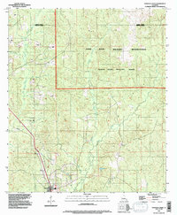
1994 Map of Dowden Creek
USGS Topo · Published 1997About this map
The Fort Polk Military Reservation dominates this 1990s landscape, encompassing the Peason Ridge Artillery Range across the rolling topography of Peason Ridge. While the northern and eastern portions of the map are defined by military activity and restricted zones, the southwestern corner reveals the northern edge of Anacoco and the intricate drainage network of the region. The landscape is carved by numerous waterways, including Dowden Creek, West Anacoco Creek, and East Anacoco Creek, with smaller tributaries like Coon Branch and Ade Branch feeding the larger basins. A notable piece of infrastructure is a major roadway marked as Under Construction, cutting a diagonal path through the southwestern quadrant and signaling the modern development of this Vernon Parish corridor during the late 20th century.
Find a feature on this map
26 named features on this map. Tap any name to fly to it.
Don’t see what you’re looking for? This feature index may not catch every label — zoom into the map to look around manually.
Map Details
Editions of this 1994 Dowden Creek Map
This is the sole edition of this map. No revisions or reprints were ever made.
Other maps of this area

1941 · Leesville
USGS Topo · 1:62,500

1941 · Slagle
USGS Topo · 1:62,500

1942 · Florien
USGS Topo · 1:62,500

1942 · Kisatchie
USGS Topo · 1:62,500

1943 · Leesville
USGS Topo · 1:62,500

1943 · Kisatchie
USGS Topo · 1:62,500

1944 · Florien
USGS Topo · 1:62,500

1944 · Slagle
USGS Topo · 1:62,500

1946 · Leesville
USGS Topo · 1:62,500

1948 · Leesville
USGS Topo · 1:62,500