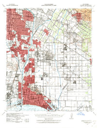
1943 Map of Downey
USGS Topo · Published 1963About this map
Industrial expansion and wartime planning intersect in this mid-century survey of the southeastern Los Angeles basin. The landscape is defined by the heavy rail infrastructure of the Southern Pacific, Union Pacific, and Atchison Topeka and Santa Fe railroads, which facilitated the rapid growth of communities like South Gate, Lynwood, and Huntington Park. While the western portion shows dense residential and commercial development, the eastern sections around La Mirada and Artesia remain largely agricultural, dominated by an extensive grid of local roads and irrigation features like the Anaheim Ditch. The transition from rural to suburban is evident in the emerging Lakewood Village and Bellflower. Notable landmarks include the County Hospital and Sunnyside Mausoleum, while the terrain rises sharply at the Puente Hills in the northeast, providing a natural boundary to the burgeoning urban sprawl toward San Pedro Bay.
Find a feature on this map
65 named features on this map. Tap any name to fly to it.
Don’t see what you’re looking for? This feature index may not catch every label — zoom into the map to look around manually.
Map Details
Editions of this 1943 Downey Map
2 editions found
Other maps of this area

1894 · Los Angeles
USGS Topo · 1:62,500

1894 · Pomona
USGS Topo · 1:62,500

1896 · Santa Ana
USGS Topo · 1:62,500

1896 · Pasadena
USGS Topo · 1:62,500

1896 · Anaheim
USGS Topo · 1:62,500

1896 · Redondo
USGS Topo · 1:62,500

1896 · Las Bolsas
USGS Topo · 1:62,500

1896 · Santa Monica
USGS Topo · 1:62,500

1896 · San Pedro
USGS Topo · 1:62,500

1896 · Downey
USGS Topo · 1:62,500