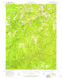
1951 Map of Downieville
USGS Topo · Published 1958About this map
Downieville and Goodyears Bar anchor the southern reaches of this 1951 survey, situated along the North Fork Yuba River. This is a landscape defined by its deep mining heritage, showing the intricate network of claims and camps that persisted into the mid-20th century. Named sites like the Standard Mine, Oxford Mine & Mill, and Magnolia Mine (Site) reveal a region where hard-rock and placer mining shaped every drainage. To the north, the terrain rises toward Mt Fillmore and Table Rock, where remote settlements like Gibsonville, Howland Flat, and Port Wine reflect the isolated nature of high-altitude gold country operations. The map documents the persistent infrastructure of the era, including the historic Hennees Pass Road and numerous mountain ranches such as Lavezzola Ranch and Marvin Ranch, which provided vital support to the local industrial economy.
Find a feature on this map
151 named features on this map. Tap any name to fly to it.
Don’t see what you’re looking for? This feature index may not catch every label — zoom into the map to look around manually.
Map Details
Editions of this 1951 Downieville Map
3 editions found
Other maps of this area

1888 · Smartsville
USGS Topo · 1:125,000

1888 · Bidwell Bar
USGS Topo · 1:125,000

1891 · Bidwell Bar
USGS Topo · 1:125,000

1891 · Downieville
USGS Topo · 1:125,000

1891 · Colfax
USGS Topo · 1:125,000

1891 · Smartsville
USGS Topo · 1:125,000

1892 · Smartsville
USGS Topo · 1:125,000

1892 · Colfax
USGS Topo · 1:125,000

1893 · Bidwell Bar
USGS Topo · 1:125,000

1893 · Downieville
USGS Topo · 1:125,000