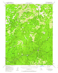
1951 Map of Downieville
USGS Topo · Published 1963About this map
Downieville and its surrounding gold-country outposts are depicted here at a mid-century moment of transition, still showing the profound footprint of the 19th-century hydraulic and lode mining industries. The map illustrates a landscape of high ridges and deep ravines where numerous historical settlements and "sites" cluster, such as Howland Flat, Port Wine, and Gibsonville. The presence of labels like Thistle Shaft (Site) and Deadwood Diggings indicates where former mining operations have left their mark on the Sierra Nevada geography. High-elevation transport is represented by the historic Hennes Pass Road, while the steep terrain is punctuated by landmarks like Table Rock and Mt Fillmore. This survey serves as a vital record for researchers tracing the evolution of Plumas and Sierra Counties, showing the relationship between early mining camps and the surviving town centers of the North Fork Yuba River canyon.
Find a feature on this map
208 named features on this map. Tap any name to fly to it.
Don’t see what you’re looking for? This feature index may not catch every label — zoom into the map to look around manually.
Map Details
Editions of this 1951 Downieville Map
3 editions found
Other maps of this area

1888 · Smartsville
USGS Topo · 1:125,000

1888 · Bidwell Bar
USGS Topo · 1:125,000

1891 · Bidwell Bar
USGS Topo · 1:125,000

1891 · Downieville
USGS Topo · 1:125,000

1891 · Colfax
USGS Topo · 1:125,000

1891 · Smartsville
USGS Topo · 1:125,000

1892 · Smartsville
USGS Topo · 1:125,000

1892 · Colfax
USGS Topo · 1:125,000

1893 · Bidwell Bar
USGS Topo · 1:125,000

1893 · Downieville
USGS Topo · 1:125,000