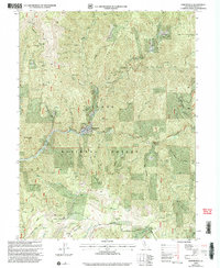
2000 Map of Downieville
USGS Topo · Published 2003About this map
Downieville serves as the focal point of this terrain, situated at the confluence of the North Fork Yuba River and the Downie River. The landscape is dominated by the steep ridges of the Tahoe National Forest, including Saddleback Ridge and Crown Ridge, which hem in a dense network of gold-mining history. The map's high concentration of mine sites, such as the Monte Cristo Mine and Gold Bluff Mine, reflects the intense subterranean exploration that defined the region’s economy long after the initial gold rush.
Find a feature on this map
71 named features on this map. Tap any name to fly to it.
Don’t see what you’re looking for? This feature index may not catch every label — zoom into the map to look around manually.
Map Details
Editions of this 2000 Downieville Map
This is the sole edition of this map. No revisions or reprints were ever made.
Other maps of this area

1891 · Downieville
USGS Topo · 1:125,000

1891 · Colfax
USGS Topo · 1:125,000

1892 · Colfax
USGS Topo · 1:125,000

1893 · Downieville
USGS Topo · 1:125,000

1894 · Colfax
USGS Topo · 1:125,000

1895 · Downieville
USGS Topo · 1:125,000

1896 · Downieville
USGS Topo · 1:125,000

1897 · Downieville
USGS Topo · 1:125,000

1898 · Colfax
USGS Topo · 1:125,000

1900 · Colfax
USGS Topo · 1:125,000