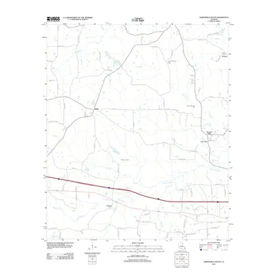
2012 Map of Downsville South
USGS Topo · Published 2012About this map
Tremont serves as a primary southern anchor for this portion of Lincoln Parish, situated along a transportation corridor that divides the drainage basins of Choudrant Creek and Squire Creek. The landscape is characterized by a mix of small crossroads communities and significant industrial infrastructure, notably the Tremont Gas Field, South Downsville Gas Field, and North Carlton Gas Field. These energy resources are woven through a rural network of family-named roads such as Averette Road and Williams Road. In the northern reaches, the community of Smurney and the nearby Smyrna Cem provide valuable touchpoints for genealogical research. To the east, the area around Frost Town and Pleasant Valley follows the winding path of Bayou Choudrant, illustrating the enduring relationship between small Louisiana settlements and the region's complex bayou systems.
Find a feature on this map
79 named features on this map. Tap any name to fly to it.
Don’t see what you’re looking for? This feature index may not catch every label — zoom into the map to look around manually.
Map Details
Editions of this 2012 Downsville South Map
This is the sole edition of this map. No revisions or reprints were ever made.
Other maps of this area

1950 · Ruston
USGS Topo · 1:62,500

1951 · Ruston
USGS Topo · 1:62,500

1952 · Calhoun
USGS Topo · 1:62,500

1953 · Chatham
USGS Topo · 1:62,500

1953 · Hodge
USGS Topo · 1:62,500

1955 · Shreveport
USGS Topo · 1:250,000

1956 · Shreveport
USGS Topo · 1:250,000
1982 · Calhoun
USGS Topo · 1:24,000
1982 · Cadeville
USGS Topo · 1:24,000
1982 · Point
USGS Topo · 1:24,000