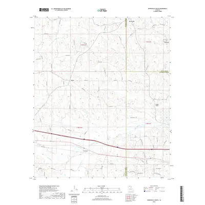
2018 Map of Downsville South
USGS Topo · Published 2018About this map
Bayou Choudrant and its tributaries, including South Choudrant Creek and Squire Cr, carve a complex drainage pattern across the boundary of Lincoln, Union, and Ouachita Parishes. The landscape is defined by the convergence of these waterways and a network of parish roads that connect small, dispersed settlements and family-named landmarks. The village of Downsville sits at the northern edge, while the southern portion of the area is anchored by the community of Tremont along the primary east-west transportation corridor.
Find a feature on this map
73 named features on this map. Tap any name to fly to it.
Don’t see what you’re looking for? This feature index may not catch every label — zoom into the map to look around manually.
Map Details
Editions of this 2018 Downsville South Map
This is the sole edition of this map. No revisions or reprints were ever made.
Other maps of this area

1950 · Ruston
USGS Topo · 1:62,500

1951 · Ruston
USGS Topo · 1:62,500

1952 · Calhoun
USGS Topo · 1:62,500

1953 · Chatham
USGS Topo · 1:62,500

1953 · Hodge
USGS Topo · 1:62,500

1955 · Shreveport
USGS Topo · 1:250,000

1956 · Shreveport
USGS Topo · 1:250,000
1982 · Calhoun
USGS Topo · 1:24,000
1982 · Cadeville
USGS Topo · 1:24,000
1982 · Point
USGS Topo · 1:24,000