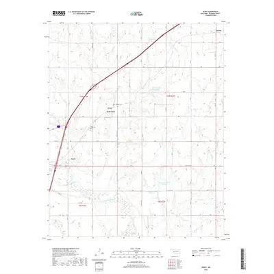
2018 Map of Doxey
USGS Topo · Published 2018About this map
Elk City and Sayre define the urban corridors of this western Oklahoma landscape, where the North Fork Red River meanders across the southwestern corner of the quadrangle. The terrain is defined by a dense network of seasonal drainages and local water management, including the Whitledge Number 1 Reservoir and Whitledge Number 2 Reservoir. Between the municipal centers, the smaller settlement of Doxey sits near the Old Doxey Cem, illustrating the historical distribution of early Beckham County communities. The map detail highlights significant transportation routes such as Merrick Pass and Cemetery Rd, alongside water features like Coffee Bean Cr and Timber Cr. This survey captures the transition from structured township grids to the natural, eroded breaks leading toward the river valley, providing a clear record of land use and local hydrology.
Find a feature on this map
30 named features on this map. Tap any name to fly to it.
Don’t see what you’re looking for? This feature index may not catch every label — zoom into the map to look around manually.
Map Details
Editions of this 2018 Doxey Map
This is the sole edition of this map. No revisions or reprints were ever made.
Other maps of this area

1955 · Clinton
USGS Topo · 1:250,000

1957 · Clinton
USGS Topo · 1:250,000

1960 · Sayre
USGS Topo · 1:62,500

1961 · Willow
USGS Topo · 1:62,500

1961 · Retrop
USGS Topo · 1:62,500

1961 · Elk City
USGS Topo · 1:62,500

1985 · Elk City
USGS Topo · 1:100,000

1987 · Elk City
USGS Topo · 1:24,000
1987 · Hocker
USGS Topo · 1:24,000
1989 · Carter West
USGS Topo · 1:24,000