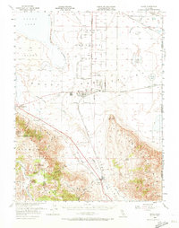
1954 Map of Doyle
USGS Topo · Published 1973About this map
The Sierra Ordnance Depot dominates the desert basin of Honey Lake Valley on this 1954 survey, reflecting the significant military presence in Lassen County during the mid-20th century. The settlement of Herlong serves as the hub for this sprawling military reservation, situated at the base of the Skedaddle Mountains and the edge of Honey Lake. This map captures a landscape defined by industrial and military logistics, where the Western Pacific and Southern Pacific railroads converge to move goods through the valley.
Find a feature on this map
54 named features on this map. Tap any name to fly to it.
Don’t see what you’re looking for? This feature index may not catch every label — zoom into the map to look around manually.
Map Details
Editions of this 1954 Doyle Map
3 editions found

Other maps of this area

1886 · Honey Lake
USGS Topo · 1:250,000

1886 · Granite Range
USGS Topo · 1:250,000

1890 · Sierraville
USGS Topo · 1:125,000

1891 · Honey Lake
USGS Topo · 1:250,000

1891 · Reno
USGS Topo · 1:125,000

1892 · Sierraville
USGS Topo · 1:125,000

1893 · Honey Lake
USGS Topo · 1:250,000

1893 · Reno
USGS Topo · 1:125,000

1894 · Granite Range
USGS Topo · 1:250,000

1894 · Sierraville
USGS Topo · 1:125,000