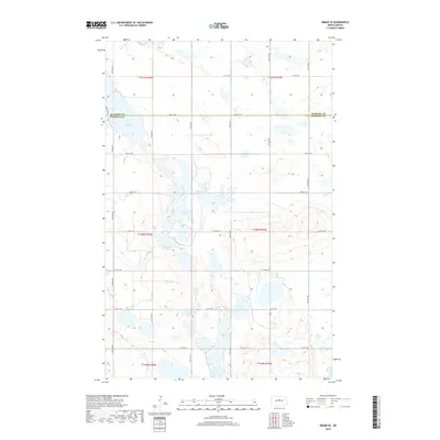
2018 Map of Drake SE
USGS Topo · Published 2018About this map
Lake Richard and Sand Lake dot this northern plains landscape, characterizing the glacial pothole region along the border of McHenry and Sheridan counties. This 2018 survey reveals a terrain defined by internal drainage, where water bodies like Frankhauser Lake and Moorehead Lake gather in the low-lying basins between prairie swells. The rural infrastructure follows a rigid section-line grid, as seen in the alignment of 24th St NE and 31st St NE, which serve the isolated farmsteads scattered throughout the townships. The sparse distribution of named water features like Guyes Lake highlights the importance of localized water sources in this agricultural corridor, providing a clear view of the modern land-use patterns across the McHenry and Sheridan County line.
Find a feature on this map
20 named features on this map. Tap any name to fly to it.
Don’t see what you’re looking for? This feature index may not catch every label — zoom into the map to look around manually.
Map Details
Editions of this 2018 Drake SE Map
This is the sole edition of this map. No revisions or reprints were ever made.
Other maps of this area

1930 · Drake
USGS Topo · 1:62,500

1940 · Aylmer
USGS Topo · 1:62,500

1946 · Sheyenne Lake
USGS Topo · 1:48,000

1947 · Lincoln Valley
USGS Topo · 1:62,500

1947 · Sheyenne Lake
USGS Topo · 1:62,500

1950 · Sheyenne Lake
USGS Topo · 1:24,000

1951 · Anamoose SW
USGS Topo · 1:24,000

1954 · McClusky
USGS Topo · 1:250,000

1958 · McClusky
USGS Topo · 1:250,000
1958 · Anamoose
USGS Topo · 1:24,000