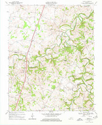
1968 Map of Drake
USGS Topo · Published 1977About this map
The looping meanders of Drakes Creek and its major tributaries, the West Fork and Middle Fork, define the agrarian character of this region south of Bowling Green during the late 1960s. The landscape is a network of rural settlements and crossroads hubs including Drake, Hillsdale, and Temperance, many established around small family-named roads like Murray Road and Goodrum Road.
Find a feature on this map
55 named features on this map. Tap any name to fly to it.
Don’t see what you’re looking for? This feature index may not catch every label — zoom into the map to look around manually.
Map Details
Editions of this 1968 Drake Map
2 editions found
Other maps of this area

1921 · Bowling Green
USGS Topo · 1:62,500

1923 · Bowling Green
USGS Topo · 1:62,500

1928 · Adolphus
USGS Topo · 1:48,000

1931 · Adolphus
USGS Topo · 1:62,500

1942 · Gallatin
USGS Topo · 1:100,000

1951 · Woodburn
USGS Topo · 1:24,000

1951 · Franklin
USGS Topo · 1:24,000

1952 · Rockfield
USGS Topo · 1:24,000

1954 · Drake
USGS Topo · 1:24,000
1954 · Polkville
USGS Topo · 1:24,000