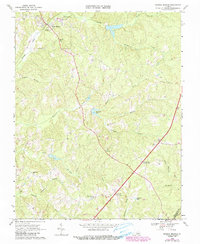
1968 Map of Drakes Branch
USGS Topo · Published 1990About this map
Drakes Branch serves as the focal point of this rural Virginia landscape, where the town's early infrastructure is marked by a Water Tank, Sewage Disposal plant, and local Substations. The surrounding countryside is deeply etched with a network of stream valleys, including Twittys Creek and Horsepen Creek, which eventually drain toward the South Meherrin River near the border of Charlotte and Mecklenburg counties. This area reflects a traditional Piedmont settlement pattern, with rural life organized around established congregations and schools. Genealogists will find several notable landmarks, from the Bacon District Sch to a series of country churches like Tabernacle Ch and Organ Hill Ch. The presence of the Lookout Tower at Crafton Gate suggests the importance of forest management in this heavily wooded region during the mid-20th century.
Find a feature on this map
32 named features on this map. Tap any name to fly to it.
Don’t see what you’re looking for? This feature index may not catch every label — zoom into the map to look around manually.
Map Details
Editions of this 1968 Drakes Branch Map
3 editions found
Other maps of this area

1891 · Farmville
USGS Topo · 1:125,000

1892 · Appomattox
USGS Topo · 1:125,000

1893 · Farmville
USGS Topo · 1:125,000

1947 · Roanoke
USGS Topo · 1:250,000

1953 · Greensboro
USGS Topo · 1:250,000

1954 · Greensboro
USGS Topo · 1:250,000

1954 · Clover
USGS Topo · 1:62,500

1955 · Chase City
USGS Topo · 1:62,500

1956 · Charlotte Court House
USGS Topo · 1:62,500

1958 · Keysville
USGS Topo · 1:62,500