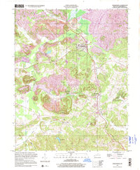
1997 Map of Drakesboro
USGS Topo · Published 2001About this map
Strip mines and industrial activity define the landscape of Muhlenberg County during this era, concentrated heavily around the railroad corridor and the town of Drakesboro. The map documents a complex network of resource extraction, from the extensive strip mine operations near Bevier and Nonnell to the Tipple and scattered Oil Wells found further south near Beech Creek. This industrial footprint exists alongside established rural communities and historic centers of worship, such as Hazel Creek Ch and Leigh Chapel.
Find a feature on this map
32 named features on this map. Tap any name to fly to it.
Don’t see what you’re looking for? This feature index may not catch every label — zoom into the map to look around manually.
Map Details
Editions of this 1997 Drakesboro Map
This is the sole edition of this map. No revisions or reprints were ever made.
Other maps of this area

1909 · Hartford
USGS Topo · 1:62,500

1909 · Central City
USGS Topo · 1:62,500

1911 · Drakesboro
USGS Topo · 1:48,000

1911 · Dunmor
USGS Topo · 1:48,000

1913 · Drakesboro
USGS Topo · 1:62,500

1914 · Dunmor
USGS Topo · 1:62,500

1952 · Greenville
USGS Topo · 1:24,000

1953 · Drakesboro
USGS Topo · 1:24,000

1953 · Rosewood
USGS Topo · 1:24,000

1953 · Central City West
USGS Topo · 1:24,000