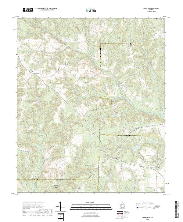
2024 Map of Draneville
USGS Topo · Published 2024About this map
Draneville and Friendship anchor this rural landscape in western Georgia, where the headwaters of multiple creek systems converge across four county lines. The terrain is defined by the branching tributaries of Muckalee Creek, Lanahassee Creek, and Choctahatchee Creek, which carve a rolling network of ridges through Marion County and its neighbors. This map captures the persistent rural character of the region, where family and community heritage are preserved in numerous local landmarks.
Find a feature on this map
53 named features on this map. Tap any name to fly to it.
Don’t see what you’re looking for? This feature index may not catch every label — zoom into the map to look around manually.
Map Details
Editions of this 2024 Draneville Map
This is the sole edition of this map. No revisions or reprints were ever made.
Other maps of this area

1950 · Buena Vista
USGS Topo · 1:24,000

1950 · Buena Vista
USGS Topo · 1:62,500

1955 · Buena Vista
USGS Topo · 1:24,000
1955 · Buena Vista
USGS Topo · 1:62,500

1955 · Phenix City
USGS Topo · 1:250,000

1957 · Phenix City
USGS Topo · 1:250,000

1958 · Phenix City
USGS Topo · 1:250,000

1971 · Ellaville North
USGS Topo · 1:24,000

1971 · Tazewell South
USGS Topo · 1:24,000
1972 · Preston
USGS Topo · 1:24,000