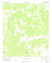
1973 Map of Draneville
USGS Topo · Published 1975About this map
Draneville and the surrounding agricultural lands of Marion County are depicted here in the early 1970s, showcasing a landscape defined by small rural hubs and an intricate drainage system. The map captures a point in time where local life centered around community landmarks like Mt Carmel Ch and its adjacent Mt Carmel Cem. The terrain is characterized by the convergence of several significant watercourses, including Muckalee Creek, Lanahassee Creek, and Choctahatchee Creek, which dictate the local topography and road patterns.
Find a feature on this map
20 named features on this map. Tap any name to fly to it.
Don’t see what you’re looking for? This feature index may not catch every label — zoom into the map to look around manually.
Map Details
Editions of this 1973 Draneville Map
This is the sole edition of this map. No revisions or reprints were ever made.
Other maps of this area

1950 · Buena Vista
USGS Topo · 1:24,000

1950 · Buena Vista
USGS Topo · 1:62,500

1955 · Buena Vista
USGS Topo · 1:24,000
1955 · Buena Vista
USGS Topo · 1:62,500

1955 · Phenix City
USGS Topo · 1:250,000

1957 · Phenix City
USGS Topo · 1:250,000

1958 · Phenix City
USGS Topo · 1:250,000

1971 · Ellaville North
USGS Topo · 1:24,000

1971 · Tazewell South
USGS Topo · 1:24,000
1972 · Preston
USGS Topo · 1:24,000