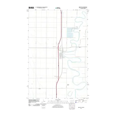
2011 Map of Drayton
USGS Topo · Published 2011About this map
The Red River of the North winds in sharp, serpentine oxbows along the border of North Dakota and Minnesota, anchoring the settlement of Drayton. This 2011 survey reveals a landscape defined by industrial and agricultural infrastructure, where the river's flow is managed by the Drayton Dam and North Drayton Dam. Transportation corridors are central to the area's layout, featuring the Herrick Interchange and a network of rural routes such as County Rd 2 and County Rd 7. On the periphery, smaller locales like Herrick and Robbin sit among the grid of township roads. The map provides specific locations for local landmarks including the Drayton Cemetery and Drayton Municipal Airport, reflecting the organized development of Pembina County in the early 21st century.
Find a feature on this map
31 named features on this map. Tap any name to fly to it.
Don’t see what you’re looking for? This feature index may not catch every label — zoom into the map to look around manually.
Map Details
Editions of this 2011 Drayton Map
This is the sole edition of this map. No revisions or reprints were ever made.
Other maps of this area

1918 · Acton
USGS Topo · 1:62,500

1939 · Drayton
USGS Topo · 1:62,500

1939 · Glasston
USGS Topo · 1:62,500

1941 · Drayton
USGS Topo · 1:62,500

1941 · Glasston
USGS Topo · 1:62,500

1943 · Grafton
USGS Topo · 1:62,500

1952 · Thief River Falls
USGS Topo · 1:250,000

1956 · Thief River Falls
USGS Topo · 1:250,000

1957 · Thief River Falls
USGS Topo · 1:250,000
1960 · Big Woods NW
USGS Topo · 1:24,000