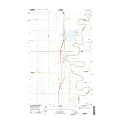
2014 Map of Drayton
USGS Topo · Published 2014About this map
The Red River of the North winds in tight, serpentine oxbows along the border of North Dakota and Minnesota, anchoring the landscape around Drayton. This river-defined corridor, captured in the mid-2010s, reveals a highly structured agricultural grid that transitions into the riparian forest along the water's edge. The town of Drayton serves as the primary hub, with its municipal grid extending toward the Drayton Municipal Airport and the local Drayton Cem. Small outlying points like Robbin and Herrick indicate the persistent footprint of rural settlement in the Red River Valley. The presence of Old ND-44 and various numbered section roads like 80th St NE highlights the importance of surface transport for the region's farming economy, while the river itself remains the dominant geographical feature, carving a complex path through Pembina and Walsh counties.
Find a feature on this map
44 named features on this map. Tap any name to fly to it.
Don’t see what you’re looking for? This feature index may not catch every label — zoom into the map to look around manually.
Map Details
Editions of this 2014 Drayton Map
This is the sole edition of this map. No revisions or reprints were ever made.
Other maps of this area

1918 · Acton
USGS Topo · 1:62,500

1939 · Drayton
USGS Topo · 1:62,500

1939 · Glasston
USGS Topo · 1:62,500

1941 · Drayton
USGS Topo · 1:62,500

1941 · Glasston
USGS Topo · 1:62,500

1943 · Grafton
USGS Topo · 1:62,500

1952 · Thief River Falls
USGS Topo · 1:250,000

1956 · Thief River Falls
USGS Topo · 1:250,000

1957 · Thief River Falls
USGS Topo · 1:250,000
1960 · Big Woods NW
USGS Topo · 1:24,000