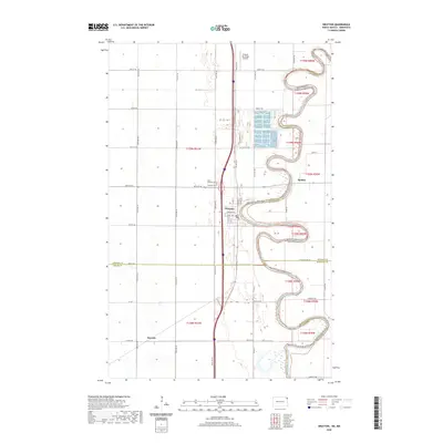
2020 Map of Drayton
USGS Topo · Published 2020About this map
Drayton and its tight, serpentine river bends anchor this 2020 map along the border of North Dakota and Minnesota. The Red River of the N carves an exceptionally winding path here, serving as the natural boundary between Pembina and Kittson counties. This hydrological pattern dominates the landscape, creating a series of deep oxbow-like peninsulas that challenge straight-line road development. While the town center of Drayton remains a focal point near Old Hwy 44, smaller named areas like Robbin and Herrick provide useful reference points for local history. Cultural markers such as the Drayton Cem and Saint Edward Cem sit just west of the river, while the Drayton Municipal Airport occupies the flatter terrain to the north, illustrating the mix of agricultural utility and aviation infrastructure in this Red River Valley corridor.
Find a feature on this map
37 named features on this map. Tap any name to fly to it.
Don’t see what you’re looking for? This feature index may not catch every label — zoom into the map to look around manually.
Map Details
Editions of this 2020 Drayton Map
This is the sole edition of this map. No revisions or reprints were ever made.
Other maps of this area

1918 · Acton
USGS Topo · 1:62,500

1939 · Drayton
USGS Topo · 1:62,500

1939 · Glasston
USGS Topo · 1:62,500

1941 · Drayton
USGS Topo · 1:62,500

1941 · Glasston
USGS Topo · 1:62,500

1943 · Grafton
USGS Topo · 1:62,500

1952 · Thief River Falls
USGS Topo · 1:250,000

1956 · Thief River Falls
USGS Topo · 1:250,000

1957 · Thief River Falls
USGS Topo · 1:250,000
1960 · Big Woods NW
USGS Topo · 1:24,000