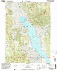
2004 Map of Drews Reservoir
USGS Topo · Published 2007About this map
Drews Reservoir dominates this landscape in southern Lake County, Oregon, where the water is held at a spillway elevation of 4,915 feet. This 2004 revision reflects a high-desert environment deeply integrated with the Fremont National Forest, showing a complex system of seasonal and year-round water sources such as Salt Spring, Kerwin Spring, and Dip Spring. The presence of the Hay Creek Ranch near the northern shore illustrates the area's ongoing ranching heritage amidst the topographic variety of Drews Valley and the Willow Creek Hills. Access to the interior is marked by primitive and improved routes like Dent Creek Road and Kernan Road, which navigate the drainages of Drews Creek and Willow Creek. This map is particularly useful for identifying land management boundaries, including the South Standard Parallel and specific forest inholdings.
Find a feature on this map
29 named features on this map. Tap any name to fly to it.
Don’t see what you’re looking for? This feature index may not catch every label — zoom into the map to look around manually.
Map Details
Editions of this 2004 Drews Reservoir Map
This is the sole edition of this map. No revisions or reprints were ever made.
Other maps of this area

1955 · Klamath Falls
USGS Topo · 1:250,000

1958 · Klamath Falls
USGS Topo · 1:250,000

1960 · Strawberry Butte
USGS Topo · 1:62,500

1960 · Fishhole Mtn
USGS Topo · 1:62,500

1964 · Drews Reservoir
USGS Topo · 1:24,000

1964 · Cox Flat
USGS Topo · 1:24,000
1964 · Dog Lake
USGS Topo · 1:24,000

1964 · Cougar Peak
USGS Topo · 1:24,000
1964 · Fitzwater Point
USGS Topo · 1:24,000

1964 · Drews Gap
USGS Topo · 1:24,000