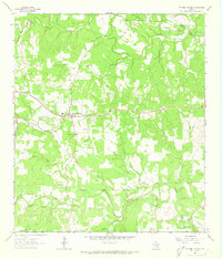
1986 Map of Dripping Springs
USGS Topo · Published 1986About this map
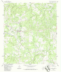
Dripping Springs serves as the focal point of this mid-1980s landscape, situated where the limestone-cut drainage of Barton Creek and Onion Creek divide the terrain. This period shows the community during a phase of growth, evidenced by the established Dripping Springs High School and the Athletic Field. Local history is anchored by the Fitzhugh Cem to the north and the Phillips Cem to the south, while Walnut Spring and Kirby Spring suggest the importance of groundwater in this part of the Hill Country. Numerous Gravel Pit sites are scattered throughout the quadrangle, particularly along the creek beds, reflecting the active extraction industry of the era. To the southeast, Camp Ben McCulloch remains a significant landmark near the crossing of Gatlin Creek, while Wallace Mtn provides a distinctive rise above the surrounding valleys.
Find a feature on this map
35 named features on this map. Tap any name to fly to it.
Don’t see what you’re looking for? This feature index may not catch every label — zoom into the map to look around manually.
Map Details
Editions of this 1986 Dripping Springs Map
This is the sole edition of this map. No revisions or reprints were ever made.
Historical Maps of Dripping Springs Through Time
7 maps found