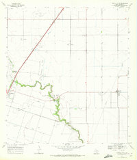
1969 Map of Driscoll East
USGS Topo · Published 1972About this map
Clara Driscoll Oil Field and the neighboring North Clara Driscoll Oil Field define the industrial character of this South Texas landscape in the late 1960s. The map illustrates a region dominated by energy extraction and agricultural settlement, where gas wells and oil fields are interspersed with rural homesteads and specialized centers like the Coastal Bend Youth City. The meandering course of Petronila Creek provides the primary natural drainage through the territory, cutting a serpentine path across the coastal plain.
Find a feature on this map
12 named features on this map. Tap any name to fly to it.
Don’t see what you’re looking for? This feature index may not catch every label — zoom into the map to look around manually.
Map Details
Editions of this 1969 Driscoll East Map
2 editions found
Other maps of this area

1924 · Petronilla
USGS Topo · 1:62,500

1925 · Robstown
USGS Topo · 1:62,500

1950 · Corpus Christi
USGS Topo · 1:250,000

1954 · Orange Grove
USGS Topo · 1:62,500

1954 · Robstown
USGS Topo · 1:62,500

1954 · Kingsville
USGS Topo · 1:62,500

1954 · Petronila
USGS Topo · 1:62,500

1956 · Corpus Christi
USGS Topo · 1:250,000

1960 · Corpus Christi
USGS Topo · 1:250,000

1966 · Corpus Christi
USGS Topo · 1:250,000