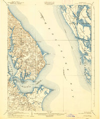
1905 Map of Drum Point
USGS Topo · Published 1938About this map
Cove Pt. and the surrounding Chesapeake shoreline define this landscape at the turn of the century, where the maritime economy of the Patuxent River meets the rural crossroads of Calvert and Dorchester counties. The map records a time when travel was heavily dictated by the water, evidenced by the prominent Steamboat Route cutting across the Chesapeake Bay and landings like Spencers Wharf. Small bay-side communities such as St. Leonard, Lusby, and Solomons Id appear as modest hubs linked by narrow overland routes, while the eastern shore is dominated by the marshy stretches of Taylors Island and Robinson Neck. This survey preserves the early configuration of Millstone Landing and Pearson long before mid-century changes transformed the southern tip of the peninsula. Topography is meticulously noted, from the heights of Point of Rocks to the intricate network of tidal guts like Punch Island Creek.
Find a feature on this map
61 named features on this map. Tap any name to fly to it.
Don’t see what you’re looking for? This feature index may not catch every label — zoom into the map to look around manually.
Map Details
Editions of this 1905 Drum Point Map
4 editions found

Other maps of this area

1892 · Leonardtown
USGS Topo · 1:62,500

1892 · Drum Point
USGS Topo · 1:62,500

1892 · Prince Frederick
USGS Topo · 1:62,500

1892 · Piney Point
USGS Topo · 1:62,500

1893 · Sharps Island
USGS Topo · 1:62,500

1894 · Piney Point
USGS Topo · 1:62,500

1894 · Point Lookout
USGS Topo · 1:62,500

1895 · Prince Frederick
USGS Topo · 1:62,500

1895 · Leonardtown
USGS Topo · 1:62,500

1895 · Nomini
USGS Topo · 1:125,000