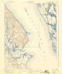
1905 Map of Drum Point
USGS Topo · Published 1943About this map
The Patuxent River meets the Chesapeake Bay in this turn-of-the-century coastal survey, capturing the maritime geography of southern Maryland before modern development transformed the shoreline. Steamboat commerce defines the era, with a clearly marked Steamboat Route navigating between the deep harbors of Solomons and the eastern shores of Taylors Island. Along the western bank, small landings such as Spencers Wharf and Millstone Landing serve as critical hubs for local trade and transport.
Find a feature on this map
65 named features on this map. Tap any name to fly to it.
Don’t see what you’re looking for? This feature index may not catch every label — zoom into the map to look around manually.
Map Details
Editions of this 1905 Drum Point Map
4 editions found

Other maps of this area

1892 · Leonardtown
USGS Topo · 1:62,500

1892 · Drum Point
USGS Topo · 1:62,500

1892 · Prince Frederick
USGS Topo · 1:62,500

1892 · Piney Point
USGS Topo · 1:62,500

1893 · Sharps Island
USGS Topo · 1:62,500

1894 · Piney Point
USGS Topo · 1:62,500

1894 · Point Lookout
USGS Topo · 1:62,500

1895 · Prince Frederick
USGS Topo · 1:62,500

1895 · Leonardtown
USGS Topo · 1:62,500

1895 · Nomini
USGS Topo · 1:125,000