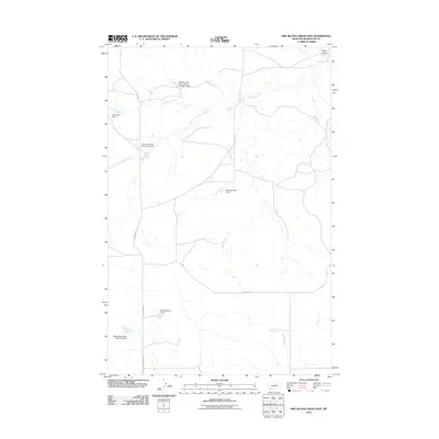
2011 Map of Dry Blood Creek East
USGS Topo · Published 2011About this map
Dry Blood Creek and its southern fork dominate this section of Petroleum County, where the landscape is defined by an extensive network of water management features. The topography reveals a series of named earthen dams, including the Dry Blood Dam, Brady Number 4 Dam, and the Resettlement FSA Number 3 Dam, the latter of which points to the federal legacy of the Farm Security Administration's land utilization projects in Montana. Local transit is facilitated by rural routes such as Dovetail Rd and Valentine Rd, which cross the drainage basins of South Fork Dry Blood Creek and Brush Creek. In the northeast corner, the terrain drops toward Carter Coulee, illustrating the distinctive coulee formations common to the region's semi-arid rangeland.
Find a feature on this map
14 named features on this map. Tap any name to fly to it.
Don’t see what you’re looking for? This feature index may not catch every label — zoom into the map to look around manually.
Map Details
Editions of this 2011 Dry Blood Creek East Map
This is the sole edition of this map. No revisions or reprints were ever made.
Other maps of this area

1954 · Lewistown
USGS Topo · 1:250,000

1959 · Lewistown
USGS Topo · 1:250,000

1985 · Brown Spring
USGS Topo · 1:24,000

1985 · Valentine
USGS Topo · 1:24,000
1985 · Davis Spring
USGS Topo · 1:24,000

1986 · Ingals Dam
USGS Topo · 1:24,000

1986 · Dry Blood Creek West
USGS Topo · 1:24,000

1986 · Winnett North
USGS Topo · 1:24,000

1986 · Dry Blood Creek East
USGS Topo · 1:24,000
1986 · Cat Creek NW
USGS Topo · 1:24,000