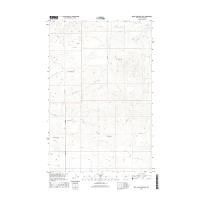
2017 Map of Dry Blood Creek East
USGS Topo · Published 2017About this map
Dry Blood Creek and its southern fork carve through this stretch of Petroleum County, where the landscape is defined by drainage patterns and remote prairie roads. In the southern portion of the map, the Ashley Cemetery serves as a small but significant marker of the area's local history, situated just north of the winding Tincan Hill Road. The terrain transitions into the Shale Coulee to the west, a distinct geological feature characteristic of this central Montana region. This area remains largely defined by the Public Land Survey System grid, with large township blocks such as t17n r27e and t16n r27e providing the structural framework for the ranches and homesteads that rely on water sources like Brush Creek. Connectivity is maintained by a network of gravel routes, including Valentine Road and Dovetail Road, which trace the high ground and divide the various creek basins.
Find a feature on this map
14 named features on this map. Tap any name to fly to it.
Don’t see what you’re looking for? This feature index may not catch every label — zoom into the map to look around manually.
Map Details
Editions of this 2017 Dry Blood Creek East Map
This is the sole edition of this map. No revisions or reprints were ever made.
Other maps of this area

1954 · Lewistown
USGS Topo · 1:250,000

1959 · Lewistown
USGS Topo · 1:250,000

1985 · Brown Spring
USGS Topo · 1:24,000

1985 · Valentine
USGS Topo · 1:24,000
1985 · Davis Spring
USGS Topo · 1:24,000

1986 · Ingals Dam
USGS Topo · 1:24,000

1986 · Dry Blood Creek West
USGS Topo · 1:24,000

1986 · Winnett North
USGS Topo · 1:24,000

1986 · Dry Blood Creek East
USGS Topo · 1:24,000
1986 · Cat Creek NW
USGS Topo · 1:24,000