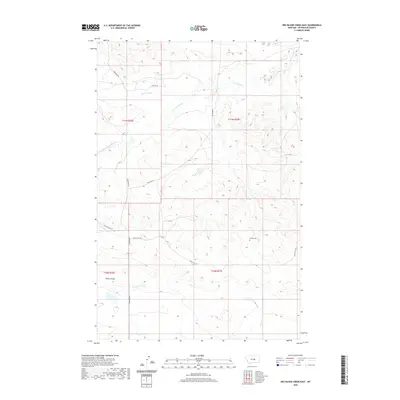
2020 Map of Dry Blood Creek East
USGS Topo · Published 2020About this map
Ashley Cem sits as a solitary landmark amidst the drainages of Petroleum County, marking a site of local genealogical interest in this remote landscape. The terrain is defined by the branching waters of Dry Blood Cr and the S Fork Dry Blood Cr, which carve through the high plains toward Shale Coulee. This 2020 survey illustrates a sparsely populated region where life and transport revolve around a few key corridors, including the north-south Valentine Rd and several primitive routes like Tincan Hill Rd and Welter Divide Rd. The map provides a detailed view of the section lines and township boundaries, such as t17n r27e, that structure this part of the Montana interior. Small seasonal tributaries like Brush Cr further delineate the coulees and ridges of the northern plains.
Find a feature on this map
14 named features on this map. Tap any name to fly to it.
Don’t see what you’re looking for? This feature index may not catch every label — zoom into the map to look around manually.
Map Details
Editions of this 2020 Dry Blood Creek East Map
This is the sole edition of this map. No revisions or reprints were ever made.
Other maps of this area

1954 · Lewistown
USGS Topo · 1:250,000

1959 · Lewistown
USGS Topo · 1:250,000

1985 · Brown Spring
USGS Topo · 1:24,000

1985 · Valentine
USGS Topo · 1:24,000
1985 · Davis Spring
USGS Topo · 1:24,000

1986 · Ingals Dam
USGS Topo · 1:24,000

1986 · Dry Blood Creek West
USGS Topo · 1:24,000

1986 · Winnett North
USGS Topo · 1:24,000

1986 · Dry Blood Creek East
USGS Topo · 1:24,000
1986 · Cat Creek NW
USGS Topo · 1:24,000