
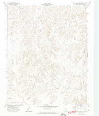
1971 Map of Dry Creek SE
USGS Topo · Published 1974About this map
Indian Creek and Chicken Creek carve deep drainage patterns through this portion of Roberts County, defining a landscape utilized heavily for both ranching and petroleum extraction in the early 1970s. The topographic detail shows the concentrated placement of an Oil Well and multiple Oil Wells across the eastern uplands, indicating the area's industrial importance during the Texas energy boom.
Find a feature on this map
9 named features on this map. Tap any name to fly to it.
Don’t see what you’re looking for? This feature index may not catch every label — zoom into the map to look around manually.
Map Details
Editions of this 1971 Dry Creek SE Map
This is the sole edition of this map. No revisions or reprints were ever made.
Other maps of this area

1954 · Amarillo
USGS Topo · 1:250,000

1958 · Amarillo
USGS Topo · 1:250,000

1971 · Dry Creek South
USGS Topo · 1:24,000

1971 · Dry Creek NE
USGS Topo · 1:24,000

1971 · Dry Creek North
USGS Topo · 1:24,000

1971 · Pampa NW
USGS Topo · 1:24,000

1972 · Horse Creek North
USGS Topo · 1:24,000

1972 · Pampa NE
USGS Topo · 1:24,000

1972 · Miami
USGS Topo · 1:24,000
1972 · Horse Creek South
USGS Topo · 1:24,000